Structural Geology
Structural geology is the study of how rocks deform through faulting, fracturing, folding, and strain. It is important for understanding calderas because calderas form through large-scale volcanic collapse and crustal deformation. Features such as ring faults, fractures, and tilted blocks help geophysicists interpret the subsurface structure and evolution of a caldera system.
Stress and strain strongly control caldera formation. As magma accumulates beneath a volcano, rocks deform elastically, brittlely, or ductilely depending on depth and rock strength. In the shallow crust, brittle failure can produce ring faults and fractures that control caldera collapse and create pathways for magma and hydrothermal fluids. At greater depths, rocks behave more ductilely and can surround partially molten magma reservoirs.
Structural geology is also important for interpreting geophysical data because faults often place different rock types next to each other, creating measurable physical contrasts. For example, intrusive igneous rocks may have different density, magnetic properties, seismic velocities, and electrical resistivity compared to surrounding sedimentary or altered rocks. Fractured and hydrothermally altered zones may also appear as low-resistivity or low-seismic-velocity regions.
In extensional settings such as the Rio Grande Rift and the, normal faulting and regional stress fields influence the geometry of volcanic structures. Understanding these structural features helps geoscientists better interpret seismic, gravity, magnetic, and resistivity data and improve models of magma movement and caldera evolution.
-Mahmoud
Earth Interior/Plate Tectonics
Earth’s interior displays chemical and structural divisions. Crust is composed of felsic and intermediate rocks (continents, high in SiO2 & Al2O3), and mafic rocks (ocean floors, high in MgO & FeO). Mantle is primarily ultramafic rock (very high in MgO & FeO), with small amounts of partial melt between mineral grains. The core is Fe, Ni, and a small percentage of lighter elements (Si, S, and/or O). Structurally, the crust and upper mantle comprise the lithosphere, which is brittle at the surface and ductile below ~10-15 km. At 40-70 km deep, the asthenosphere is just mantle and behaves ductilely. The core is divided into a liquid outer shell and a solid inner core. The structural contrast of lithosphere and asthenosphere allows for plate tectonics.
Plate tectonics cools Earth’s interior. Accreting rocky materials in the vacuum of space from dust to catastrophic impacts led to Earth’s differentiated core and internal heat. Afterward, radioactive decay of fast (e.g. 26Al and 60Fe) and slow isotopes (e.g. 235U) continued to build heat. Despite radiation to space, conduction to the crust, and convection in the mantle, the Earth retains vast heat. The fastest cooling comes through advection, or subduction of cold crust. As the lithosphere couples with the top of the asthenosphere, thick plates of rock diverge, converge, and grind past each other, exposing hot melt to the surface and subducting cold plates.
Plate motions dictate where magma chambers can develop. Divergence often occurs in oceanic plates, observed as mid-ocean ridges. As plates rift apart, they thin, decompressing the mantle and leading to melting. Convergence subducts dense oceanic plates into the mantle below buoyant plates. Volatiles release from the downgoing slab and rise through dry rock, encouraging partial melting. Melt networks pool into magma chambers as volcanic arcs such as the Andes. Aside from plate boundaries, mantle plumes rise in the center of plates, like Hawai’i.
At Valles Caldera, interactions of the Jemez Lineament (JL) and Rio Grande Rift (RGR) led to melt. The JL is a line of volcanism thought to represent an old subduction arc from 1.65-1.5 Ga. When the Farallon Plate subducted under North America ~70-40 Ma, its fresh volatiles and heat might have followed old volcanic plumbing. Later, as the RGR began ~35 Ma, the crust thinned and triggered mantle melting. At this intersection, Valles was primed for ascending melt to heat, melt, assimilate, and store within the continental crust.
-George
Calderas, such as the Valles Caldera in the Rio Grande Rift near the Jemez Lineament, are directly impacted by Earth’s internal heat and tectonic processes. These processes control magma generation, movement, storage, and ascension. High heat flow is driven from residual heat during the Earth’s formation, radiogenic heating, and mantle convection. These systems sustain the magma chambers and hydrothermal activity beneath the caldera.
Plate tectonics control the settings of which calderas form, which include rift zones, subduction zones, and hotspots. Each setting uniquely impacts magma production, magma chemistry, eruption style, and the volume of magma chambers. In rift environments like the Rio Grande Rift, crustal extension leads to lithospheric thinning and mantle melting. This allows for elevated heat flow and magmatic ascent through the crust. Faulting can also cause volcanic deformation that can cause calderas to collapse.
The Valles Caldera location provides the tectonic conditions necessary for magma generation and geothermal activity. The regional extension thinned the crust, increased heat flow, and created pathways for magma and hydrothermal fluids. Understanding this tectonic framework helps scientists interpret the geometry of magma chambers, hydrothermal systems, and fault networks, while geophysical methods such as seismic imaging, heat-flow measurements, and magnetic surveys can be used to map these subsurface features.
-Sky
Both (we agreed on the image)
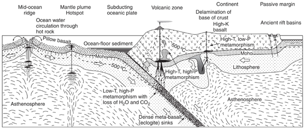
Schematic diagram of plate divergence and convergence, as well as mantle pluming. Note that the lithosphere includes the uppermost mantle. From Principles of Igneous and Metamorphic Petrology by Philpotts and Ague.
Sources:
Philpotts, A.A. & Ague, J.R., 2009, Principles of Igneous and Metamorphic Petrology, 2nd edition
Marshak, The Theory of Plate Tectonics
Marshak, The Earth, from Surface to Center
Goff, F. & Kelley, S.A., 2021, Facts and hypotheses regarding the Miocene–Holocene Jemez Lineament, New Mexico, Arizona and Colorado, Geology of the Mount Taylor Area.
https://
Volcanic Processes
Incandescent molten rock, referred to as magma when beneath the surface and lava after it emerges, form fountains from caters, faults and volcanoes. This melt transition from below to above Earth’s surface is a volcanic eruption- the study of these systems is intrinsically linked to the evolution and formation of Valles Caldera as well as its surrounding landscape. The SiO2 wt % and volatile chemistry of a volcanic chamber will dictate eruption style as these tetrahedra polymerize into chains that stiffen the melt, increasing its viscosity and explosiveness if there is the presence of high volatile contents; whereas basalts is less viscous and allows gases to easily leave melt resulting in less explosive eruption style. Melt can be produced in various ways- decompression melting (adiabatic) through the rising of rock and dropping of pressure occurring at rift zones, plumes and ridges, Flux melting which occur as hydrous and mostly at subduction zones/ convergent margins. The resulting melt rock that “freezes” is considered an igneous rock and that can range from pyroclastic debris (ash, pumice and fragments shot violently into the atmosphere) to simple lava flows.
The Valles Caldera sits where the rift meets the Jemez lineament, overprinting the older Toledo embayment, and its setting records a complex magmatic history that includes eight major volcanoes formed after the caldera itself with several magmatic related events prior such as Volcan Diablo and Toledo Caldera. The primary Valles caldera-forming eruption (~1.25 Ma) was triggered by an earthquake, and a single vent shot a “pumice rain” ~20 km into the atmosphere. As more vents opened, the projectile force dropped, and the eruption ultimately expelled roughly 300 times the volume of Mount St. Helens until the eruptive columns collapsed. That collapse dropped the roof along ring fractures, because the magma that had supported it from below was now gone; the same way over-pumping an aquifer causes the ground above to subside. The collapse was uneven, dropping the east side some 4,000–5,000 feet but the west only 1,000–2,000, and afterward residual and newly recharged magma pushed the floor back up to form Redondo Peak. The most recent activity, the El Cajete sequence (~55 ka), erupted felsic magma and shifted from explosive to effusive, implying a change in its volatile content. Understanding how magma like this is generated, transported, differentiated, and erupted is exactly what lets geophysicists read the subsurface, since each method targets a property these processes control; Gravity measures density (anomalies in mGal), seismic methods measure wave velocity (m/s), magnetics measures susceptibility, resistivity and magnetotellurics measure electrical resistivity (Ω·m). Volcanic processes are vital for interpreting geophysical data from eruption style, magma composition and any subsequent hydrothermal alteration ultimately govern density, velocity and resistivity.
-Endreina
Sedimentary Geological Processes
The Valles Caldera is a region of active volcanism, regional extension, and continuous sedimentary deposition. Within the intra-caldera basin, alluvial, fluvial, lacustrine, and volcanic processes rapidly erode and bury the history of the caldera, limiting geologic study and observation from the surface. This paper evaluates how integrating multiple geophysical datasets - specifically gravity, seismic reflection, and electromagnetics - resolves lithological ambiguities, demonstrating that a multi-physics approach is required to accurately model dynamic caldera basinal frameworks.
Alluvial
Alluvial deposition refers to loose, unconsolidated sediments that are transported by running water and deposited into a low-energy environment, such as floodplains, riverbeds, deltas, and alluvial fans (Rajapakse, 2016). At the Valles Caldera, higher topography areas formed by the volcanic activity, allows for runoff and streams to constantly erode terrain and deposit sediments. Some of this deposition and erosion may bury structures, such as faults, geologic contacts, and ring fractures at the caldera. Geophysical surveying can be used to identify these hidden boundaries when drilling and excavation are too invasive, inefficient, or costly. For example, the results of a gravity survey can be interpreted as changes in bulk density over an area. Generally, the rock types from least dense to most dense are sedimentary, metamorphic, and igneous (Dobrin, 1976). At the Valles Caldera, the Precambrian crystalline basement rocks and Paleozoic limestones (~2.6-2.8 g/cm³) provide excellent bulk density contrast to the unconsolidated Quaternary alluvial basin fill (~2.3-2.5 g/cm³) depending on the fill depth.
In addition to density, gravity results can also give insight to the depths of materials, as the force of gravity that the gravimeter will be attracted to decreases as it moves further away from the source body. And since a gravimeter is not limited by depth, it would also be useful at the caldera to map the relative thickness of sedimentary basins. Similarly, seismic surveys can give insight into the relative densities, porosities, and permeability. Higher velocities often indicate denser rock types and vice versa (Earle, 2019). Seismic reflection/refraction is also a widely used method to survey sedimentary basins using compressional wave velocity, shear wave velocity, and acoustic impedance. For example, if units have contrasting acoustic impedance, like a well-stratified paleolacustrine mudstone and a poorly consolidated and porous dry gravel, portions of the sound wave will be reflected back as an echo (Chowdhury, 2020).
There are exceptions and overlap between these categories. For example, there are extrusive igneous rocks at the Valles Caldera that are lower densities than some sedimentary rocks, such as the non-welded Bandelier tuff. This means that a gravity survey alone without additional constraints could be confusing when determining thicknesses of less dense units. Additional geophysical data such as electromagnetics or magnetics can show better contrast of chemical or electrical properties of materials, such as the magnetic susceptibility and resistivity.
Fluvial and Lacustrine
The San Antonio Creek and East Fork Jemez River have continuously modified the landscape of the caldera post-resurgence, further incising banks and depositing fluvial sediments. Since the caldera is also an enclosed topographic low, many lakes have formed and disappeared over time but the three largest lakes formed as a result of blocked drainages and enclosed lakes from early volcanism. Seismic activity from volcanism also impacted sedimentation in fluvial and lacustrine environments.
The differences in conductivity in these units is also important to understand even if we can’t trace back to their parent rock because conductivity gives us information about the porosity, permeability, and chemical composition of the units. For example, within the region of the Valles Caldera, sedimentary units with higher conductivity can indicate the presence of siltstones and sandstones (Tracy, 2025). In addition, the presence of magmatic melt or groundwater will also show as more conductive than the same unit in a non-melt or dry state since the dissolved ions can allow electricity to move more freely.
Geothermal
Electromagnetic field methods such as electromagnetic (EM), and magnetotelluric (MT) are also widely used for detecting geothermal systems as they can have an anomalously high conductive smectite/zeolite clay cap over geothermal reservoirs and magmatic systems where sediments are altered from the high temperatures (Schwering, 2022). The highly conductive clay zones and a surrounding unaltered, highly resistive crystalline basement rock can provide stark contrast in EM data. The presence of geothermal systems can also deposit sediments, such as calcium carbonate and silica at the surface. The Valles Caldera has an active geothermal system still producing heat and producing hydrothermal deposits at its surface, including sulfuric-acid mud pots, steaming volcanic fumaroles, and boiling water. The Sulphur Springs area within the Preserve has seven named sulfuric acid springs within a 20-acre area. There are likely multiple extinct hydrothermal deposits that have ceased to precipitate out minerals due to structural changes over time, such as the activation of new faults or changes in the hydrologic gradient. These processes can transport the hot fluids and minerals away from their source. This is an important process to understand, especially if companies wanted to use the geothermal reservoir as a resource. Utilizing geophysical data effectively before deep drilling decreases the economic risk of drilling and missing commercial temperatures.
-Katherine
Citations
Chowdhury, A., 2020, Seismic reflection methods for sedimentary basin analysis: Journal of Geophysical Research, v. 14, no. 3, p. 112–125.
Cumming, W., 2007, Conceptual models of geothermal systems: Example of a thermal manifestation, in Proceedings, 32nd Workshop on Geothermal Reservoir Engineering, Stanford University, Stanford, California, SGP-TR-182, 8 p.
Dobrin, M.B., 1976, Introduction to Geophysical Prospecting (3rd ed.): New York, McGraw-Hill, 630 p.
Drakos, P.G., 2007, Longitudinal profile and sedimentary deposits of San Antonio Creek, Valles Caldera, New Mexico: New Mexico Bureau of Geology and Mineral Resources Report, 12 p.
Earle, S., 2019, Physical Geology (2nd ed.): Victoria, British Columbia, BCcampus.
Evans, A. 1995, Gravity Studies of Two Silicic Volcanic Complexes (Doctoral dissertation, Open University).
Gavel, M.M., Amato, J.M., Ricketts, J.W., Kelley, S., Biddle, J.M., and Delfin, R.A., 2021, Thermochronological transect across the Basin and Range/Rio Grande rift transition: Contrasting cooling histories in contiguous extensional provinces: Geosphere, v. 17, no. 6, p. 1807–1839, Gavel et al. (2021).
Goff, F., Gardner, J.N., Reneau, S.L., Kelley, S.A., Kempter, K.A., and Lawrence, J.R., 2011, Geologic map of the Valles Caldera, Jemez Mountains, New Mexico: New Mexico Bureau of Geology and Mineral Resources Geologic Map 79 booklet, 30 p., https://
Rajapakse, C., 2016, Dynamics of alluvial deposition in low-energy terrestrial environments: Earth-Science Reviews, v. 152, p. 45–60.
Reneau, S.L., Drakos, P.G., and Katzman, D., 2004, Post-resurgence lakes of the Valles Caldera, New Mexico: New Mexico Geological Society Annual Spring Meeting, v. 55, p. 21–32.
Schwering, P., Hinz, N., Winn, C., Milton, A., Lopeman, J., Takuya, S., Cumming, W., Sewell, S., Sabin, A., Zimmerman, J., Blake, K., Bedrosian, P., Downs, C., Siler, D., Folsom, M., Kraal, K., and Matson, G., 2022, Basin and Range Investigation for Developing Geothermal Energy: Exploration Data: Geothermal Data Repository, Sandia National Laboratories, dataset, Schwering et al. (2022).
Tracy, L., 2025, Electrical conductivity variations in southwestern caldera basins: Geophysical Journal International, v. 238, no. 2, p. 891–904.
Hydrology
Studying hydrology is crucial for understanding a caldera as it plays a vital role in volcanic processes, shapes geomorphology, and can be used to map the subsurface when accompanied with geophysics. When water interacts with magma, it can lead to explosive eruptions or volcanic events. Because calderas are bowl shaped, they trap water that then infiltrates the subsurface through fractures, faults and porous rock. This water is often heated by a shallow magma reservoir, causing it to circulate through the subsurface and generating a hydrothermal system. These systems generate highly pressurized hydrothermal reservoirs, which manifest as geysers, fumaroles, hot springs, and mud pots on the surface. As this groundwater is forced to the surface, fens are created.
When accompanied with geophysics, hydrology can provide useful insights into the structural geology of a caldera. By determining where water becomes trapped, we can make inferences about rock types and geologic features. Water saturates areas where there is open space. For this reason, water often saturates faults, fractures, porous rocks, etc., and pools above less permeable features. These could include welded tuff, clay, or an intrusive volcanic rock layer. Within calderas, ring faults often trap water. By mapping water, these geologic features can be mapped. There are a wide variety of geophysical methods that can be used to search for water within the subsurface. Areas that are saturated with water often have lower resistivity values and higher conductivity values compared to the surrounding rock. These differences can be effectively mapped using resistivity surveys, conductivity surveys, and magnetotelluric surveys. Dielectric permittivity typically increases with water saturation, which makes GPR effective for mapping water. Seismic surveys can be also used for mapping water, as P-wave velocities increase when pore spaces are filled with water as opposed to gas. While these survey methods are used to directly find water, other methods can be used to find spaces where water might be. Highly fractured regions have lower density, which can be identified using gravity surveys. Zones that have been hydrothermally altered can be demagnetized, which can be displayed on magnetic surveys. Passive source seismic surveys can be used to identify faults.
-Maxwell
- Gavel, M. M., Amato, J. M., Ricketts, J. W., Kelley, S., Biddle, J. M., & Delfin, R. A. (2021). Thermochronological transect across the Basin and Range/Rio Grande rift transition: Contrasting cooling histories in contiguous extensional provinces. Geosphere, 17(6), 1807–1839. 10.1130/ges02381.1
- Schwering, P., Hinz, N., Winn, C., Milton, A., Lopeman, J., Takuya, S., Cumming, W., Sewell, S., Sabin, A., Zimmerman, J., Blake, K., Bedrosian, P., Downs, C., Siler, D., Folsom, M., Kraal, K., & Matson, G. (2022). Basin and Range Investigation for Developing Geothermal Energy: Exploration Data. DOE Geothermal Data Repository; Sandia National Laboratories. 10.15121/2513910